
The Bimonthly Water Quality Sampling Program is ORSANCO’s long-term water quality monitoring program for the Ohio River. The monitoring program began in 1975 and has a continuous record through the present day at 32 locations: 16 stations on the main stem of the Ohio River and 16 points near the mouth of major tributaries. The program’s six-sample annual design provides long-term trend monitoring of the Ohio River while maintaining an ability to evaluate attainment of water quality criteria. Samples are collected every second month, in January, March, May, July, September, and November.
Water Quality Parameters
- Ammonia as Nitrogen
- Biochemical Oxygen Demand
- Bromide
- Chloride
- Cyanide
- Dissolved Organic Carbon
- Dissolved Oxygen
- Hardness (as CaCO3)
- Nitrate Nitrite
- Orthophosphate as P
- pH
- Specific Conductivity
- Sulfate
- Temperature
- Total Dissolved Solids
- Total Kjeldahl Nitrogen
- Total Nitrogen
- Total Organic Carbon
- Total Phenolics
- Total Phosphorus
- Total Suspended Solids
- Turbidity
Sample Locations
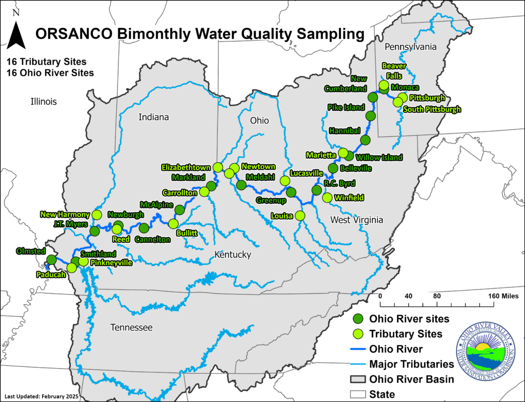
Most samples are collected from United States Army Corps of Engineers Locks and Dams, the remainder are collected from bridge or bank locations. The Bimonthly Sampling Program Monitoring Stations are (Ohio River confluence mile points are given for tributary stations with tributary mile points enclosed in parenthesis):
- Allegheny River at Pittsburgh, Ohio River Mile 0.0, (-7.4)
- Monongahela River at South Pittsburgh, Ohio River Mile 0.0, (-4.5)
- Beaver River at Beaver Falls, Ohio River Mile 25.4, (-5.3)
- Ohio River at Monaca, Ohio R. Mile 26.3
- Ohio River at New Cumberland, Mile 54.4
- Ohio River at Pike Island, Mile 84.2
- Ohio River at Hannibal, Mile 126.4
- Ohio River at Willow Island, Mile 161.8
- Muskingum River at Marietta, Ohio River Mile 172.2, (-0.8)
- Ohio River at Belleville, Mile 203.9
- Kanawha River at Winfield, Ohio River Mile 265.7, (-31.1)
- Ohio River at R.C. Byrd, Mile 279.2
- Big Sandy River at Louisa, Ohio River Mile 317.1, (-20.3)
- Ohio River at Greenup, Mile 341
- Scioto River at Lucasville, Ohio River Mile 356.5, (-15)
- Ohio River at Meldahl, Mile 436.2
- Little Miami River at Newtown, Ohio River Mile 464.1, (-7.5)
- Licking River at Covington, Ohio River Mile 470.2, (-4.5)
- Great Miami River at Elizabethtown, Ohio River Mile 491.1, (-5.2)
- Ohio River at Markland, Mile 531.5
- Kentucky River at Carrollton, Ohio R. Mile 545.8, (-4.1)
- Ohio River at McAlpine, Mile 606.8
- Salt River at Bullitt, Ohio R. Mile 629.8, (-0.8)
- Ohio River at Cannelton, Mile 720.7
- Green River at Reed, Ohio R. Mile 784.2, (-8.7)
- Ohio River at Newburgh, Mile 776
- Ohio River at J.T. Myers, Ohio R. Mile 846
- Wabash River at New Harmony, Ohio River Mile 848, (-51.5)
- Ohio River at Smithland, Mile 918.5
- Cumberland River at Pinkneyville, Ohio River Mile 920.4, (-16)
- Tennessee River at Paducah, Ohio River Mile 934.5, (-6)
- Ohio River at Olmsted L&D, Mile 964.8
Grab Sample Methods
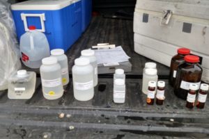
River water samples are collected as near to the centerline of the river as possible from lockchamber guidewalls, bridges, and in some cases from raw water intake lines. To sample from outside structures an acid, distilled, and river water-rinsed bailer, stainless steel bucket, or Kemmerer sampler is used with sufficient nylon rope attached to reach the river surface. Samples are transferred from the collection device to a likewise triple-rinsed ten-liter plastic carboy. The sample water is distributed from the carboy to sample bottles, each containing preservative if required by the analytical methods to be employed.
Sensors are deployed in-situ to collect dissolved oxygen, pH, temperature, specific conductance, and turbidity data.
For more information on the Bimonthly Water Quality Sampling Program, please contact Riley Lanfear.